Tuesday, June 7, 2016

New York Harbor and the Trip Up The Hudson River to Kingston, NY - Day 266-267

 June 6-7, 2016
Day 266-267

We wound up staying an extra day at Great Kills Yacht Club because Sunday was predicted to have severe thunderstorms all day and high winds.  Since we still had some large bodies of water to transit, either one would have kept us in place.  As it turned out the day was windy, but the thunderstorms did not appear until later in the evening.  Either way, we stayed on Sunday.

Monday we cast off our lines and began the trip to Manhatten and on up the Hudson River to Kingston, NY.   There had been another PDQ named Azura at the dock near us for the last couple of days, and they left about an hour and a half before we were ready to go.  They had told us that they were only going about half the distance we were planning for the day.

Leaving The Great Kill Yacht Club on Staten Island.


Navigating around the south side of Staten Island we soon approached the Verrazano Narrows Bridge and the entrance to New York Harbor.


We stayed to the east near Brooklyn to avoid the busiest part of the harbor and soon approached Governor's Island and Manhattan.


We navigated near the Statue of Liberty and Ellis Island.


We still had to contend with dodging numerous ferries and other commercial boat traffic on our way up the Hudson on the west side of Manhattan.


The New World Trade Center dominates the skyline of lower Manhattan.


We were passing Yonkers when we came up behind Diva Di, another PDQ 34.  They had purchased their boat about they same time we had last year and spent last summer doing the "Down East Loop" which goes up the Hudson to Lake Champlain and then on to the St. Lawerance River, and then east to Nova Scotia, then south down the coast of Maine.  They had stored their boat in Massachusetts for the winter and had just picked it up a couple of weeks ago to begin the Great Loop.  They were also headed to the PDQ meetup in Brewerton, NY as we were. They hailed us and we chatted on the VHF for a few minutes.  I felt like I knew them even though I had never met them because I followed their blog last year while they were on the Down East Loop.


Diva Di has the 75 horsepower engines as opposed to our 100 horsepower engines, so their cruise is not as fast as ours.  We soon left them behind.  Shortly thereafter we also passed Azura who had left from Great Kills ahead of us.  They also have the 75 horsepower engines.


We began to see some interesting lighthouses.


We passed West Point on the way up the river.


The scenery was amazing with the river running between huge granite mountains.  The water was often over 100 feet deep.


We reached another interesting lighthouse that marked the entrance to the harbor at Kingston.  We traveled 107 miles that day, averaging over 16 mph.  We were able to get such a good average speed because we had reached lower Manhatten about 2 1/2 hours before high tide, so we were able to ride a boost from the river current as the tide moved up the river all the way up to Kingston.


When we pulled into the dock at Kingston and I brought the engines to idle and the port engine died.  We could not restart it, so I had to dock with only one engine.  This also happened when we pulled into Great Kills and one more time a few weeks ago.  After the first incident, I changed all of the primary fuel filters, figuring that at low speed the engine was starving for fuel.  After that, it ran fine until the last two stops.  There is also a secondary fuel filter on each engine that filters to a smaller micron size than the primaries, so I figured that the secondary filter needed to be changed.  I neither had a filter aboard nor did I know how to change it if I did, so I set about finding someone to come to the boat with a filter and change it.

With the help of the marina, I finally found a diesel mechanic who was willing to come that day, but did not have the filter, it would have to be ordered for the next day, so we were at Kingston for another day.  He came and took the filter off of the engine and it was quite dirty, so he took it with him to order another one.  Big mistake!  Apparently since the filter was not in place, and even though the valve was shut off, one of the attached fuel lines apparently drained into the pan under the engine, filling the boat with diesel fumes.  We spent the rest of the evening trying with limited success to air out the boat.

The next morning I called the mechanic and told him he had to come immediately and clean up, which he did.  Later he found a filter, came back and installed it.  Since the boat smelled of diesel Sharon decided to walk into Kingston and do some sightseeing while I stayed on the boat to air it out, deal with the mechanic, and defrost the refrigerator.  She walked the town and took some photos.

To get to town from our marina she had to walk over a nearby suspension bridge.  Sharon reports that the terrain in Kingston is all uphill, both ways!


There were two Catholic churches in town, St. Peter's and St. Mary's.  Sharon took some pictures at both.


St. Peter's School.

This Celtic Cross was at St. Mary's.  It was dedicated to the Irish people who died during the Potato Famine in the 1840's and 1850's.


Sunday, June 5, 2016

One More Day Holding Then Our First Ocean Transit - Day 264-265

June 4-5, 2016
Day 264-265

We were planning to go from Atlantic City to Staten Island on Friday, but we awoke to more fog and higher winds than originally forecast, so we decided to stay put for another day.  We took an Uber to the Tanger Outlets in Atlantic City to look and shop.  The outlet area here is huge and it takes up quite a few city blocks.  Sharon found some new boat shoes and several other bargains, and I browsed the Bass Pro Shop there.  That night we had a clear sunset and when we went to bed that we could see the casinos across the water from our marina, a good sign since for the last few nights the fog had been so heavy we could not see them.


We work up Saturday morning to no fog and light winds as predicted, so it was a go!  We threw off the lines, left our marina, and headed for the inlet along wth a line of other boats who had decided that this was the day to go "outside" as well.  This was my first time navigating an inlet, but Abscomb Inlet is wide, deep, and well marked, so it was no problem at all.


We mostly stayed about three miles from shore for the entire trip.  There was not a lot to see but waves, other boats, and the distant "Jersey Shore" towns.


At one point we saw one of the boats that advertise whale watching tours a couple of miles farther out and while we were watching we could see a whale swimming away from the boat and causing huge splashes with his tail.  I zoomed way in with my camera and took several photos although I could not see what I was taking.  Once I got them into the computer I found one that showed the end of the whale's tail and cropped it out of the photo.  Not a good shot but thar she blows!


We finally reached the Great Kills Yacht Club on Staten Island, NY after 86 miles on the open ocean and 13 miles up the Raritan Bay to Great Kills Harbor.  It was a long 99-mile day!  One of the guys at the yacht club drove us to a nearby Catholic church for Mass where we got to witness the first Mass of a newly ordained priest.  That was a treat!  Afterward, we walked back to the yacht club and stopped along the way for dinner.  After dinner as we approached our yacht club we saw someone being arrested and having his bag searched.  I am glad the yacht club is gated!


Thursday, June 2, 2016

Atlantic City, NJ and Holding - Day 261 - 263

May 31 to June 3, 2016
Day 261-263

Well, for most of this trip since we left Gloucester we have been waiting for favorable weather for two days for every one day we travel.  This is not a great way to make rapid progress.  Hopefully, that will change soon since we need to be in Brewerton in upstate New York on the 17th.

While getting ready to leave our marina in Cape May the damage is not structural but there is fiberglass damage that will have to be repaired.  That guy needs some boat handling lessons.


Our original plan was to leave Cape May and make an ocean transit to Staten Island, NY, but the wind and waves were higher for the next few days than we wanted to experience.  We decided to take the New Jersey Intracoastal Waterway instead, even though most people chose not to.  The reason is that the waterway is shallow, has many twists and turns, and is not very well maintained. In addition New Jersey pleasure boaters and not very courteous to other boats and constantly whiz by without slowing down, causing uncomfortable wakes.  We decided that making some progress north was worth the trouble, so we went.  Along the way, we passed through many "Jersey Shore" beach towns like Wildwood and Ocean City.


This bridge going into Ocean City looks like a skateboard ramp or a ski jump.


We had to pass through many low drawbridges, but they opened promptly on request and we didn't have to wait very long at any of them.


Jake and Kimi keeping a lookout for other dogs, large birds, and any other threats.


Finally, we saw the Atlantic City skyline come into view, but it was still more than an hour before we reached our marina due to the twists and turns and drawbridges along the way.


We arrived late to our marina so didn't do much but clean the boat, eat supper, and go to bed.  The next day we decided to wait for a weather window to go offshore instead of going up the ICW any further.  The facilities at the other end of the ICW did not look very attractive and they are expensive.  Even if we completed the New Jersey ICW we would still have to make a 20-mile ocean passage to get to New York harbor since there is no ICW for the last 20 miles, so we decided to wait for better conditions and try to go up in one day.

The next day while we were waiting for good weather we decided to walk to the Atlantic City Boardwalk.  We saw the old Abscomb lighthouse and rebuilt keeper's house along the way.  It is no longer in service but was built 160 years ago to mark the Abscomb Inlet which is where Atlantic City is located.


This is a view of the famous Steel Pier.  None of the rides were operating for some reason.


We watched the Beach Patrol lifeguards getting some training on the lifeboats for a while.  It caught our attention since two of our three boys had been Beach Patrol lifeguards (called Surf Rescue Technicians) in Ocean City, MD.  They did not have these boats in Ocean City so it was interesting to watch.  I didn't realize before this that when they approach the beach they turn the bow toward the surf and row backward.  There is a video below showing the process.


We decided to take one of the trolleys to see the rest of the 7-mile long Boardwalk.  I just took a few pictures along the way.


These are the famous "Rolling Chairs" first introduced to the Boardwalk in 1887.  I don't think I would like sitting in one of these while somebody pushed it around like a stroller.  I'd rather take the trolley.


After our Boardwalk tour, we decided to eat dinner at Harry's Oyster Bar at Bally's where we ran into two other boating couples that we had met in Cape May.  Small world!

We were somewhat surprised at the number of closed businesses and casinos along the Boardwalk.  We went into Bally's to get dinner and were also surprised at how run down the elevators and hallways were.  Times must be tough in Atlantic City.

We are keeping our fingers crossed that the weather forecast holds for Friday and Saturday and we are able to head up to New York harbor on Friday and then on up the Hudson on Saturday.

Cape May, NJ and Holding. Day 259-260

May 29-30, 2016
Day 259-260

We left the marina on the C&D Canal at sunup so we could navigate the Delaware Bay early while the winds are typically lighter than later in the day.  The Delaware Bay is very much a working waterway, we saw very few pleasure boats except others who were clearly traveling through like us.  We saw a nuclear power plant, numerous interesting lighthouses, and tugs pulling barges along the way.


 A first for us was that when we were within about 10 miles of Cape May we ran into a fog bank where our visibility was only 100 yards or so much of the time.  The fog was patchy, sometimes visibility was next to nothing, other times maybe a mile.  This was quite nerve-wracking for us since we had never had to navigate through a fog, relying only on the radar to spot any boat traffic and on the chart plotter to know the direction of our travel.  Luckily there were very few boats around us, although I was tracking one boat on radar near us and Sharon finally saw it through the fog so I was able to maneuver away from it.    Finally as we got near Cape May the fog lifted and we were able to enter the inlet without any problem.


We spent the rest of the afternoon exploring Cape May and saw many of the beautiful old Victorian era houses in town.  A number of the larger homes had been converted to condominiums and one bedroom units were selling for around  $500,000.00, and they were not even on the beach!  Since it was Memorial Day weekend the town and the beach were both very busy.  After our sight seeing we went to the grocery and liquor stores to reprovision.  The marina had a car service, so they dropped us off in town and when we were finished we called them and they came and picked us up.  Very nice!


This boat was at our marina when we got there.  It is a Polynesian double sailing canoe from Hawaii and had about 15 crew members.  They are on a journey to sail around the world.  


I found the following information on their website, http://www.hokulea.com/

Hōkūleʻa, our Star of Gladness, began as a dream of reviving the legacy of exploration, courage, and ingenuity that brought the first Polynesians to the archipelago of Hawaiʻi. The canoes that brought the first Hawaiians to their island home had disappeared from the earth. Cultural extinction felt dangerously close to many Hawaiians when artist Herb Kane dreamed of rebuilding a double-hulled sailing canoe similar to the ones that his ancestors sailed. Though more than 600 years had passed since the last of these canoes had been seen, this dream brought together people of diverse backgrounds and professions. Since she was first built and launched in the 1970s, Hōkūle’a continues to bring people together from all walks of life. She is more than a voyaging canoe—she represents the common desire shared by the people of Hawaii, the Pacific, and the World to protect our most cherished values and places from disappearing.

Hōkūleʻa at a Glance:
Built in Honolulu, Hawaiʻi and launched on March 8, 1975
Has sailed over 140,000 nautical miles across the Pacific
Length: 62 feet
Width: 20 feet


We stayed at the South Jersey Marina, which was quite nice.  Pictures below show some of the outdoor seating areas.  The boater's showers are like going to a spa.  Our slip gave us a nice view of the harbor which is surrounded by quaint houses (many of them were built partially over the water), restaurants, and marinas.  We sat on our flybridge that evening enjoying a nice breeze, eating fresh shrimp, and having some wine while listening to live music from a nearby restaurant.  It was a wonderful evening!


The C&D Canal Waiting for a Weather Window - Day 257 to 258

May 27-28, 2016
Day 257 to 258

Our run up to the C&D Canal from Rock Hall, MD was easy and uneventful on the Chesapeake.  We had a good time pointing out sights to each other of places we had been to by land but had never seen from the water.  Below is a picture of the lighthouse at Turkey Point, the entrance to the Elk River at the top of the bay.  It is the tallest lighthouse on the bay and has had more female keepers than any other lighthouse on the bay.


After following the Elk River for a few miles we entered the C&D Canal.  This canal is mainly for large commercial ships and connects the Chesapeake and Delaware Bays.  Once we were in the canal we were able to get quite a boost from the current flowing through there.  We normally cruise at around 17 miles per hour at 3000 RPM, but the current pushed us to over 21 miles per hour at the same RPM!


This is the bridge over the canal at Chesapeake City, MD.


Not too far past Chesapeake City we saw this boat, a 53 foot Carver, up on the rocks.  He had been traveling with a companion boat which was sitting a short distance away in the canal.  As we approached, we heard the companion boat calling the Coast Guard on the VHF radio to report the accident.  He said that the boat had suddenly taken a hard starboard turn and ran up on the rocks.  Apparently he had lost propulsion on the starboard engine at a speed of about 25 knots, causing the remaining port engine to turn the boat hard to starboard.  This may have been caused by a broken shaft or transmission problem.  They were taking on water but since they were hard up on the rocks they were in no danger of sinking.  There were five people and two dogs aboard.


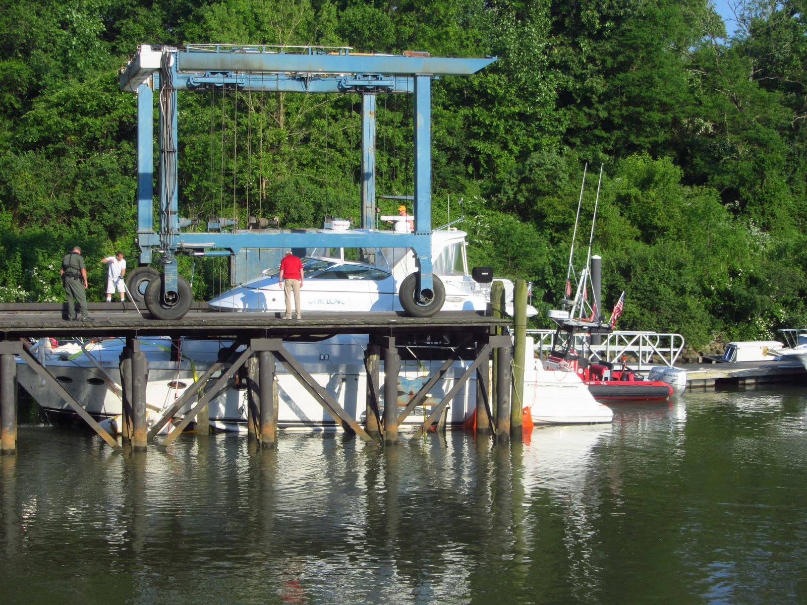
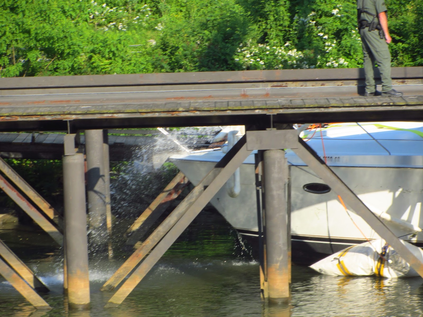
The next day we saw the same boat being towed by BoatUS into the marina where we were staying.  It had flotation bags all around it to keep it from sinking, and four gasoline water pumps pumping out the water that was coming into the boat.  It was being towed and pushed by two tow boats.  They maneuvered it into the slings of a travel lift and it was lifted from the water.  I could not see the actual damage, but could see water pouring out of the bottom of the hull near the middle of the boat.


We stayed at Summit North Marina in Bear, DE along the canal for two days waiting for a weather window that would allow us to make a comfortable 60 mile run down the wide Delaware Bay to Cape May, NJ.